A little something like this?
A lesson in Aerial Surveys in the Aleutians, AK Pen. And Kodiak Island(aka how the earth surface changes).
The state I built by plate tectonics and subsequent volcanism while glacial action is a primary driver in its being torn down. Both leave their evidence on the landscape. One way to learn about what happened here is…
The use of aerial photography and later satellite imagery has long been used by government agencies. The military is interested in strategic locations, intelligence gathering, etc. Meanwhile Geoscientists, biologists, geophysicists, cartographers, anthropologists, and archeologists all have questions that can be answered through various types of surveys before having to allocate resources to touch the ground in a region.
Given this region of the world is home to an 1100 mi. long arch of volcanoes, experiences earthquakes, and tsunamis on a globally unprecedented basis and the area has been, in some cases scraped clean of any usable soil by the last glaciation it would seem impossible odds for anything to make a living here. It may surprise you that not only are there numerous species of marine mammals, birds, salmon,etc, ect. There is a long and sorted history of human inhabitants. The Aleut have subsisted on what resources they could secure from land and sea for thousands of years in the face of these volcanoes, tsunamis, glaciers and earthquakes.
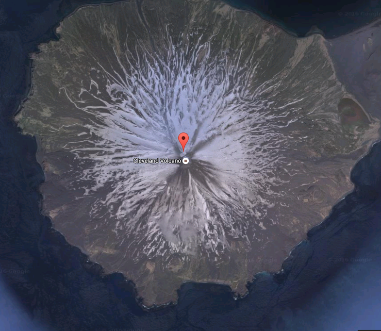
We can look at several sets of images that show different features of volcanoes (calderas, active vents, pyroclastic flows, etc.) We can use older, grainy images to new satellite, or google earth images. Which is a better tool for the job? What questions could we answer with x technology
Additionally, we can look at images with evidence of glaciated terrain and previously glaciated
terrain vs non-glaciated.
We could do a little practice together pic A, Pic B, Pic C
What do you see? Blah, blah or blah? Ok how about blah blah? Yes and what don’t you see?
The exercise would have students look at three regions within the wester maritime region
One that was clearly Volcanic
One Volcanic and previous glaciated
One w/o Volcanoes but with glaciated
Bonus(tricky)- no volcanoes or glacial
Can you tell from imagery alone what may have happened in an area?
What is your evidence for your conclusion?
How could we ‘see’ it?
Have a blank map for students to populate with the features they think they can identify and what has ‘happened’ there.
A debrief after the exercise was completed could ask some questions related to how else might we access these areas without having to go there and at a reasonable expense?
Fishing for……. Drones and high resolution mapping. Inexpensive (relatively) and accuracy achievable to +/- 10cm pretty easily.
This could lead into another exercise: How to make a map using a drone…. Then do it?
Some helpful links could be
Hey Matt! USGS Explorer has a browser for historic imagery and geological data. It’s on their site somewhere, maybe here: http://earthexplorer.usgs.gov/
And here is updated imagery on GINA as a link for Google Earth: http://kml.gina.alaska.edu
And (not sure how helpful this is for your idea but) you can use NOAA’s shorezone to fly the whole coast of AK for up to date aerial images of the whole state’s coastline: https://alaskafisheries.noaa.gov/mapping/szflex/index.html?T=SZ@L=B
Thanks Ryan! I will check those sites. M
Focusing on culturally relevant teaching as well, I think it would be cool to see how the Alaska Natives in those regions (if any had exposure to the volcanic landscapes or have experienced the shift in geographical states) interpret environmental changes. Are there stories that personify the movement of glaciers or show volcanic action?
Another note, I saw that the artifact I chose to talk about – Giinaruaq masks – were excavated from a place called the Old Savonoski site, which was originally a native village but buried by the eruption of a nearby volcano. How did Natives respond to destruction of cultures not necessarily done by human forces but by natural forces?
This will be awesome. Maps! I have personal photos of a few areas that may be of interest to use in your presentation. Also, having talked to community members of Port Heiden, for example, I know that volcanic activity, amongst other things, has impacted things such as FOOD source (caribou) in his region….
Matt, this is such a great idea and way to approach your project. I feel like I have to talk with you further to fully understand the end goals here in terms of what you what your students to ultimately understand from this (is it analyzing maps, or how surveys are created). You have laid out a lot of valuable information that will be a great lesson!
Good ideas flowing here. You might draw some inspiration from the National Geography Standard here http://nationalgeographic.org/standards/national-geography-standards/
Especially:
– How to use maps and other geographic representations, geospatial technologies, and spatial thinking to understand and communicate information
– The physical processes that shape the patterns of Earth’s surface