Desert Dreams

This map, Road Trip Culture and Wanderlust in Southern California, explores the cultural significance of local travel in Southern California and the deep connection I (and many other Southern Californians) feel with the desert. I am attempting to explore the desert and its many facets as both a physical home and a heart home. Many southern Californians share a fascination with the strange, mysterious, and surreal and have a passion for travel and exploration in the local landscape. Going for a drive, taking a roadtrip, experiencing an obscure place or activity, and exploring nature are all common pastimes for SoCal locals. As a child, taking daytrips, roadtrips, scenic drives, and hikes in the natural landscape were formative experiences for me. Anywhere within a day’s drive was a place of imagination, inspiration, and possibility. The weekend trip and the day’s drive were a magical transport for me, which allowed me to immerse myself in the beauty, sights, and sounds of the environment around me. I used this map to explore some of the strange, mythos-evoking local landmarks and the starkly beautiful and rugged local landscape of southern California. Each place on the map is a day’s drive or less from any point in southern California. All drives are meant to be done as a day or weekend mini-road trip. The common thread among all of the chosen places on the map is that they all explore some sense of mystery or wonder about the desert and surrounding areas.

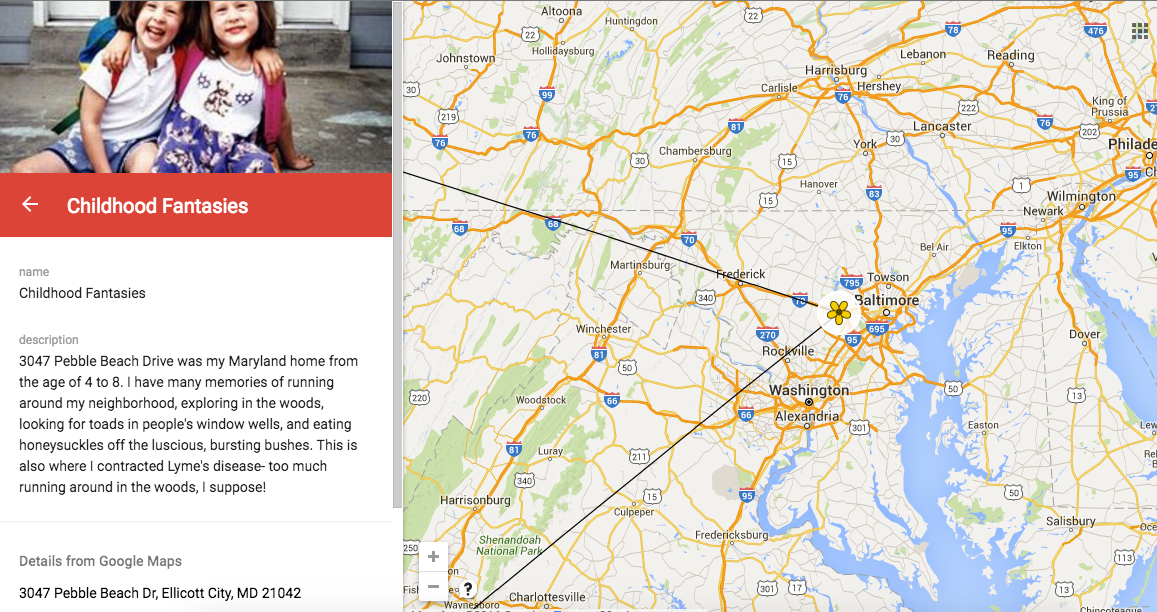
This classroom activity was a great way to explore and express creative narrative and geography with respect to sense of place. I would consider using this type of activity in the classroom because it allows for an engaging approach to research and an opportunity for students to make self discovery. I felt that the tech aspects of this project were not too challenging to learn, and that they could be successfully implemented into the classroom.

Place-based Learning – Ju-Nom Nom

In my experiences living in Juneau, it has truly proven itself to be a place to be gorged on-not oppressively, but intellectually-rich and murky in its history and development, embedded with brilliance (literally, there is gold here).

When introducing a place in which I live to others, I enjoy sharing the place through my lenses, providing channels through which the participant may both feel how I have come to be shaped by what Juneau has gratefully presented to me, and also determine for themselves, how they want to perceive this land.

On the map are six different locations around Downtown Juneau, places that I consider to be some of the best hidden gems in Juneau, connected by my love for food, sitting on a goldmine of history and knowledge. I encourage you to read the descriptions, and examine the images.

The project was made using Google MyMaps, a new resource/application which I fully embrace, especially in its potential use in Social Studies classes. For me, a place comes with emotional associations, like a bookmark in my memories. As a Third-Culture Kid (TCK) perpetually moving and moved, I try to be present in the experiences I witness, through the sounds, the smells, etc… MyMaps allows the audience to see an area, which they may already be familiar with (in my case perhaps those who grew up in Juneau), with a new perspective, a new lens to view the uniqueness of each lived experience. I believe that is something to be celebrated.

*Update 6/15/16: For some reason, several images that I did not intend to use, got tagged onto the images in certain locations (for example, the last 5 images under Seong’s automatically attached themselves) I wonder how this happens and if there is a way to fix it

Where I’m from: Kwigillingok, Kenai


Where I’m From: Kwigillingok, AK – Created with Haiku Deck, presentation software that inspires;

Although it seems like an easy assignment, this was probably the most complicating one for me. I struggle trying to define myself and it’s tough because I feel like I’m repeating the same things I’ve already stated. I was born in Bethel hospital, and was raised in the village of Kwigillingok. Out of all the regions in Alaska, I feel the Yup’ik region has been fortunate to not have the natural substances that attracted the Americans. Others weren’t so lucky. Nome had the gold. Barrow region had the oil. Bristol Bay had the salmon. Other coastal regions had fur, whale, and other resources that attracted the Russians and the Americans and eventually took over the region. The only group of people that came were the Russian Orthodox and Moravian missionaries to build schools and churches into my region. My hometown Kwig was isolated, and there weren’t that many things to do. Hunting, fishing, and picking berries were necessary in order to put food on the table. If Eskimo ice cream wasn’t made, some families used fried bread as a substitution for dessert. When there weren’t much subsistence activities going on, many youth played basketball at the ball court during the summer. The main transportation to Bethel or other villages was a small 7-seater plane, although many caravans have been introduced in the last few years. There are no roads to use automobiles there, but there are roads made of wood for bicycles and ATVs.

After spending much of my life in Kwigillingok, I decided to move to Kenai/Soldotna to attend college. About halfway through college, I got married to a girl from above the Arctic Circle who went to college there as well. We have lived there basically for the past 11 years. We now have two kids and we love taking them out to the beach. I have worked as a longshoreman for the past two years, and I typically tried to take time off during the dip-netting season. Our plan now is to move back to the village and teach.

Walking tour of Brasov, Romania

This was the first time when I used GoogleMyMaps to do a walking tour and I enjoyed every moment. I think this is a great tool to use in a Social Studies class because it will keep the students engaged and focused on their task.

As a future Science Teacher, I will definitely use HaikuDeck in my classes for previewing a unit or as an assignment for students. This will give them the opportunity to explain different processes using images and key words.

Overall, I was very excited about both of the tools that were presented today. I believe technology is an important part of teaching and we should embrace that.

Run Wild in Missoula Montana

Google Map was easy to use. I think that this would be a good tool to use in the classroom. Students could use this as a way to show the importance of place in their lives. They could combine the map and photos along with text that explains the significance of each area. Sense of place or belonging is a theme that often arises in literature so it could be an interesting interactive ancillary activity to either introduce the topic or expand discussion on the importance of place and the impact that it has on their lives and the lives of others.

My Many Places

I was really excited about this technological storytelling project for multiple reasons. First of all, I love using technology in the classroom to enhance learning and am open to learning about new methods or platforms that can help do so. Also, I liked the idea of creating a visual representation of my experiences living in so many different places. Before we were even set loose to brainstorm and explore the possibilities of our projects, I had an image in my mind of exactly what I wanted.

It wasn’t too much of a learning curve working with MyMaps- I use GoogleMaps often, so I just needed to learn how to add markers to my searched locations and then add pictures to the markers. I was excited to use personal photos of me and my family, and I learned how to collect the photo’s link in order to upload that to my marked spots.

The videos provided by our professor answered many of the questions I had. I appreciated having the visual process to guide me through the steps, and I rewinded and fast-forwarded when needed, allowing me to move at my own pace.

I watched the videos to learn how to embed my Google Maps journey in this post and am proud to share it with the public. Please enjoy the tour of my many homes!

Place- Douglas Island

This is a walking tour of downtown South Douglas Island. I grew up on “the island” as my mom calls it. My old house is spot “D” on the walking tour and I found a google image of it before it was torn down. Today, all that exists in that spot is gravel. From the tour you can see some of my favorite childhood places to explore and some more recent places that I’ve discovered as an adult. When available, I added both historical and contemporary photographs to the locations. One of the beautiful parts about Douglas is the history that exists there. I included locations that are important to my own personal history like: my former home, my elementary school, the site of my dad’s art studio where I learned to paint, my favorite garden spots, and some of my current Girl Scout Troop’s favorite field trip spots. I also included some points of cultural and historical significance like: the Douglas Reservoir and Dam, the Alaska Native Cemetery, the Treadwell mine “New Office Building,” Mt. Jumbo Gym (former school), and the Glory Hole (part of the mine). The Glory Hole Mine Ruins location includes a short video about the history of the mine as well as an additional map of the various historical sites along the Treadwell trail. I wanted to show how My Maps could be really used as a learning tool, so I also included links to more information about many of the sites.

css.php